Analyze

Tanio, N_EnviroEd Collaborative_organization

ntanio

EEC is the writing team for 10Strands,  CCEJ project for 8th grade curriculum.

EEC is organized as a collaborative (initially they were made up of over 75 organizations that include School District representation) with a board of trustees (13 members). Mary Walls, who is on a 10S writing team, is the chair of this org. In addition they have an Advisory Board. Their website lists 13 sponsors and 3 "grantors' including SoCal Edison. They describe themselves as a grassroots alliance.

The EEC seems to have officially started in Feb 2015 with their first EEC Symposium although planning meetings began in 2014 following the Stanford University Collaborative Impact Model.

Tanio, N_EnviroEd Collaborative_initiatives

ntanio

The EEC offers piad workshops--their most recent on in Winter 2022 features Mary V and Mary Walls (Board Chair of EEC) as Workshop leaders on Land Acknowledgements and Decolonializing educaiton.

The EEC's websites lists many resources (organizations, guides) focused on Environmental; Agricultural, Professional development

In addition, they sponsor a bilingual art/writing and video contest annually seemingly for school age children. Recent topics include: Air and Justice (2021); Water & Water Justice (2022)

Tanio, N_EnviroEd Collaborative

ntanio

Mission statement:  Creating a sustainable and just future through environmental learning experiences for all.

They execute their mission through funding, policy and program resources In Riverside and San Bernardino Counties

In addition they envision communities where a) every person can experience nature everyday; b) teachers and envied providers have resources; c) enviro literacy is an essential component of child development

1. WHAT IS THIS DATA RESOURCE CALLED AND HOW SHOULD IT BE CITED?

margauxf

Public Health Alliance of Southern California. California Healthy Places Index. 2019. https://healthyplacesindex.org.


© 2018 Public Health Alliance of Southern California

Permission is hereby granted to use, reproduce, and distribute these materials for noncommercial purposes, including educational, government and community uses, with proper attribution to the Public Health Alliance of Southern California including this copyright notice. Use of this publication does not imply endorsement by the Public Health Alliance of Southern California.

© 2018 California Department of Public Health (CDPH)

Permission is hereby granted to use, reproduce, and distribute these materials for noncommercial purposes, including educational, government, and community uses, with proper attribution to the CDPH, including this copyright notice. Use of this publication does not imply endorsement by the CDPH.

8. How has this data resource been critiqued or acknowledged to be limited?

margauxf

The index does not include certain neighborhood characteristics critical to health because they did not meet the criteria for inclusion (described in question 3). For instance, this included physician ratios (the number of physicians per 100,000 population) because data was missing for a majority of census tracts. In fact, the steering committee was unable to locate much data on health care access or quality at the census-tract level (only data on health care insurance coverage was available).  

 The index was previously critiqued in ways that led to a shift from framing data in terms of “disadvantage” towards a framework of “opportunity”. This led to not only a renaming of the index (from “the Health Disadvantage Index to the Healthy Places Index) but also a shift in reporting of data (e.g. highlight the percentage of the population with a BA degree or higher rather than the percentage of population without a college degree). 

The HPI is also limited in terms of the effects of confounding, with some indicators with strong evidence of health effects showing contrary associations with life expectancy at birth by census tract. The steering committee has also acknowledged that the HPI might not be accurate for census tracts undergoing rapid population change (e.g. due to immigration, rapid gentrification, or other changes).

The HPI notably does not correlate strongly with CalEnviroScreen, which the steering committee for the HPI noted failed to identify one-third of census tracts with the worst conditions for population health. The HPI is ultimately more centered on considering environmental factors as a part of overall health, rather than as a central determinant. However, this disconnect between CalEnviroScreen and the HPI may also be a reflection of the challenges environmental injustice advocates have faced in linking environmental factors to health outcomes (which might not be as visible and geographically direct as the links between health and other indicators).

5. What can be demonstrated or interpreted with this data set?

margauxf

The HPI draws data about 25 community characteristics into a single indexed HPI score. The includes sub-scores for 8 “Policy Action Areas”: Economic, Education, Housing, Health Care Access, Neighborhood, Clean Environment, Transportation, and Social Factors. These scores are meant to be used to evaluate health geographically. Each policy action area includes the following individual indicators and weights:

ECONOMIC (0.32)

  • Poverty
  • Employment
  • Income

EDUCATION (0.19)

  • Pre-school enrollment
  • High school enrollment
  • Bachelors attainment

HEALTHCARE (0.05)

  • Insured adults

HOUSING (0.05)

  • Severe cost burden low income
  • Homeownership
  • Kitchen and plumbing
  • Crowding

NEIGHBORHOOD (0.08)

  • Retail jobs
  • Supermarket access
  • Parks
  • Tree canopy
  • Alcohol establishments

CLEAN ENVIRONMENT (0.05)

  • Diesel PM
  • Ozone
  • PM2.5
  • Drinking water

SOCIAL (0.10)

  • Two parent household
  • Voting

TRANSPORTATION (0.16)

  • Healthy community
  • Automobile access

*The steering committee for the HPI sought to include race/ethnicity as a 9th policy action area, but they were prohibited from doing so by state law which does not allow California state agencies to use race as a basis for public contracting.


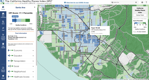
The primary HPI Index is designed to align with life expectancy at birth as a predictive measure of community health status. However, the Healthy Places mapping tool can also be used to create custom scores using different indicators. The mapping tool includes detailed definitions of each indicator.

Each indicator is linked to a policy guide, which outlines concrete actions (e.g. best practices, emerging policy options) that local jurisdictions can take to improve HPI indicators. These actions are sometimes aimed at addressing direct links between policy and an action area, and other times aimed at addressed the root causes of an action area. The mapping tool also enables filtering results by “Decision support layers” like health outcomes, health risk behaviors, race/ethnicity, climate change effects, and other layers that the alliance identifies as important for advancing “resilient, equitable communities in California”. Geographies (e.g. census tracts) can also be compared by indicator using a ranking tool. The pool function can be used to create customized aggregations of data to map (e.g. adding several census-tracts together).

4. What scales (county, regional, neighborhood, census tract) can be seen through this data resource?

margauxf

Data is available at several different scales: census-tracts, congressional districts, state assembly districts, state senate districts, cities, core based statistical areas, elementary school districts, metropolitan planning organization and medical service study areas.