Analyze

Oceania

Misria

Emerging technologies are increasingly being sought as interventions to intractable environmental and public health issues that promise to intensify on our warming planet. Genetically engineered mosquitoes could curb the impacts of mosquito-borne diseases like malaria and dengue. Solar geoengineering could use cloud thinning or aerosol scattering to reflect sunlight back into space and cool the planet. Adequate regulatory and governance mechanisms do not yet exist for these technologies, the impacts of which span international boundaries, and have the power to irreversibly alter environments. There is wide recognition from national and international bodies that decision-making processes surrounding these technologies must engage local and Indigenous communities whose lands and resources would be impacted by their trial and deployment. In response, public, community, and stakeholder “engagement” has taken center stage in the discourse on emerging environmental technology governance. Scientists and technologists are now compelled to engage publics and communities, as they recognize that some form of engagement or authorization will be requisite to the application of their technologies outside the laboratory. The language of participatory engagement abounds in scientific and governance literature on environmental technologies. These texts espouse the importance of co-design, relationship-building, shared decision-making, and mutual learning, and recognize the uneven power relations in which environmental decisions have historically been made. Yet, emergent practices of engagement leave much to be desired in terms of realizing their stated aspirations. Deficit model approaches frame publics and communities primarily as “lay people” needing to be educated before weighing in on decisions. In my fieldwork on one Pacific island where genetically modified mosquitoes are being considered for endangered bird conservation, I observed a focus group in a market research firm in which local and Indigenous residents were tested on their knowledge of invasive species biology and asked to rank radio advertisements and slogans about the modified mosquitoes. The conflation of engagement with marketing strategies and public relations campaigns prioritize the management of public perception over genuine dialogue or mutual learning. In theory, all the interest in engagement promises to open up meaningful possibilities for local and Indigenous communities to realize their rights to self-determination. In practice, strategic and instrumental approaches instead subdue opposition and manufacture consent. Legal mechanisms are needed to codify Indigenous rights in decision-making processes. Alternative approaches are needed that widen the focus beyond a single technofix to let communities define environmental challenges and collectively imagine solutions. Opposition should be read not as a barrier but as a generative site for inquiry, as often it is not the technology itself being refused but the exclusionary processes that surround its use. The most just solutions are likely to emerge from those very refusals. 

Taitingfong, Riley. 2023. "It’s all talk: how community engagement is failing in environmental technology governance." In 4S Paraconference X EiJ: Building a Global Record, curated by Misria Shaik Ali, Kim Fortun, Phillip Baum and Prerna Srigyan. Annual Meeting of the Society of Social Studies of Science. Honolulu, Hawai'i, Nov 8-11.

9. How has this data resource been critiqued or acknowledged to be limited?

annlejan7

There are missing data points within the dataset (attributed to non-reported information). This dataset has also been acknowledged to be limited in its prioritization of government data, which could have political limitations that may skew the degree of severity for disasters reported. 

8. What can be demonstrated or interpreted with this data set?

annlejan7

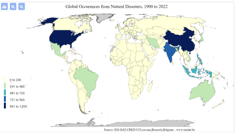
This dataset can be used to demonstrate the geographic distribution of disasters in Vietnam over time. This database recognizes multiple dimensions of disaster, including natural (typhoons, hurricanes), technological (a chemical spill, a factory explosion), and more

Image
screenshot_2022-02-22_171315.png
complex disasters such as famine.

6. How has this data resource been used in research and advocacy?

annlejan7

This resource has been used in a publication written by Hoang et al., 2018 on the economic cost of the Formosa Toxic Waste Disaster in Central Vietnam. It is specifically used within the journal article to highlight the forms in which disasters can take place within a nation, and the rising cases of industrial disasters that have afflicted vulnerable communities within the last decade. This characterization sets the stage and context for the Formosa disaster, and integrates it within a wider conversation about the effects of intensified industrialization on the environment. 

5. What steps does a user need to take to produce analytically sharp or provocative data visualizations with this data resource?

annlejan7

These datasets all involve  a strong spatial component. The presentation of such data could best be done via GIS Software, with their integration within a story map to demonstrate the importance of environmental stewardship to natural environments as well as the people who depend on such resources for their livelihoods.  For example, EPI data can be incorporated with EM-DAT’s disaster data to better understand the relationship between  a country’s EPI performance and the amount of technological disasters it observes. A country’s EPI score on Fish Stock Status can be compared with how much the nation’s GDP relies on fisheries to draw attention to discrepancies between stewardship and a country’s reliance on this resource. This process will require a user to be familiar with GIS Software and spatial plotting of data points (as the datasets themselves have not been integrated into ArcGIS), and using this software to integrate information together into meaningful maps.

4. What data visualizations illustrate how this data set can be leveraged to characterize environmental injustice?

annlejan7

[Source: EM-DAT Public] This graphic shows the prevalence of technological disasters [includes toxic spills, industrial explosions, etc.] by country. This can be used to characterize, on a transnational level, where potential industrial harms are centralized or concentrated. While it does not characterize more insidious harms, such as air pollution, it can be a direct and easy to understand measure of environmental harm distribution across the globe. 

Additionally, data is available as excel sheets, which allows users to produce their own graphics on the prevalence of disasters within a particular nation over a desired time interval. 

3. Who makes this data available and what is their mission?

annlejan7

This was developed in 1988 by personnel from the Center for Research on the Epidemiology of Disasters (CRED) within the Université catholique de Louvain (UCLouvain) with funding from the Belgian government and the World Health Organization (WHO), this data source aims to provide free open access information for users affiliated with academic organizations, non-profits, and international public organizations looking to gain understanding on the distribution  of disaster occurrences around the globe.

2. What data is drawn into the data resource and where does it come from?

annlejan7

The EMT disaster database is compiled from a wide variety of sources, including UN agencies, NGOs, insurance companies, research institutes, and press agencies. The dataset compilation process prioritizes data from UN agencies, the International Federation of Red Cross and Red Crescent Societies, and government agencies. Entries are reviewed prior to consolidation, and this process of checking and incorporating data is done on a daily basis. More routined  data checking and management also occurs at a monthly interval, with revisions made at the end of each year.