Search

Staßfurt, Saxony-Anhalt Environmental health threats

Philipp Baum

1. Long-term threats, legacy of mining
- Unstable old salt mines below Stassfurt that have to be monitored and water flows have to be management to prevent ground movement
- so far, more than 800 buildings, including an 500-year old church had to be demolished. Currently, ground movement is under control
- 27 waste heaps and contaminted sites within the city that contain many very hazadous chemical compunds. They were never properly cleaned up

2. Long-term threats, ongoing causes
- by-products of salt mining and refining are collected in large landfills that leak salt into sorrounding areas. There are no plans how these landfills can be remediated, they have to be mananged indenfinitely
- soil erosion of arable land around the city by high intensity farming of crops for livestock production and bioenergy
- toxic waste produced by waste incarceration plant is pumped into former salt mining caves where it solidifies and becomes impossible to recover

3. Short term threats
- explosion in bionenergy plant in 2020
- leakage of ammonia at public street in 2014
- pollution of river bode with ammonia and chloride by CHIECH Soda, massive fish kills every summer
- air pollution, cause unknown, probably mostly by metalworks industry

Staßfurt, Saxony-Anhalt Setting: Salt-mining

Philipp Baum

Staßfurt is a small city in the East German Bundesland Saxony-Anhalt with about 24 thousand inhabitants. Like many cities and villages in the area, it faces huge demographic problems: The population is shrinking rapidly, consists mostly of older people, unemployment is high, percentage of highly educated people is low. The city has a long history of salt mining that goes back to the 13th century. Many inhabitants proudly refer to Staßfurt as the "Cradle of potash-mining" ("Wiege des Kalibergbaus"). Unfilled salt mining shafts that were flooded by groundwater had to be abandoned and started to cave in. Over 800 buildings in the city center had to be demolished because of instabilities, among them a 500-year old church. Nevertheless, salt mining and a metallic industry that developed alongside it is still the largest economic sector in Staßfurt. The city is still permeated by an old mining culture that becomes visible in traditional festivals, clubs (Bergmannsverein e.V. Staßfurt) and the playing of traditional miner's song on offical occasions (Steigerlied).

9. How has this data resource been critiqued or acknowledged to be limited?

annlejan7

There are missing data points within the dataset (attributed to non-reported information). This dataset has also been acknowledged to be limited in its prioritization of government data, which could have political limitations that may skew the degree of severity for disasters reported. 

8. What can be demonstrated or interpreted with this data set?

annlejan7

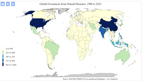
This dataset can be used to demonstrate the geographic distribution of disasters in Vietnam over time. This database recognizes multiple dimensions of disaster, including natural (typhoons, hurricanes), technological (a chemical spill, a factory explosion), and more

Image
screenshot_2022-02-22_171315.png
complex disasters such as famine.

6. How has this data resource been used in research and advocacy?

annlejan7

This resource has been used in a publication written by Hoang et al., 2018 on the economic cost of the Formosa Toxic Waste Disaster in Central Vietnam. It is specifically used within the journal article to highlight the forms in which disasters can take place within a nation, and the rising cases of industrial disasters that have afflicted vulnerable communities within the last decade. This characterization sets the stage and context for the Formosa disaster, and integrates it within a wider conversation about the effects of intensified industrialization on the environment. 

5. What steps does a user need to take to produce analytically sharp or provocative data visualizations with this data resource?

annlejan7

These datasets all involve  a strong spatial component. The presentation of such data could best be done via GIS Software, with their integration within a story map to demonstrate the importance of environmental stewardship to natural environments as well as the people who depend on such resources for their livelihoods.  For example, EPI data can be incorporated with EM-DAT’s disaster data to better understand the relationship between  a country’s EPI performance and the amount of technological disasters it observes. A country’s EPI score on Fish Stock Status can be compared with how much the nation’s GDP relies on fisheries to draw attention to discrepancies between stewardship and a country’s reliance on this resource. This process will require a user to be familiar with GIS Software and spatial plotting of data points (as the datasets themselves have not been integrated into ArcGIS), and using this software to integrate information together into meaningful maps.

4. What data visualizations illustrate how this data set can be leveraged to characterize environmental injustice?

annlejan7

[Source: EM-DAT Public] This graphic shows the prevalence of technological disasters [includes toxic spills, industrial explosions, etc.] by country. This can be used to characterize, on a transnational level, where potential industrial harms are centralized or concentrated. While it does not characterize more insidious harms, such as air pollution, it can be a direct and easy to understand measure of environmental harm distribution across the globe. 

Additionally, data is available as excel sheets, which allows users to produce their own graphics on the prevalence of disasters within a particular nation over a desired time interval. 

3. Who makes this data available and what is their mission?

annlejan7

This was developed in 1988 by personnel from the Center for Research on the Epidemiology of Disasters (CRED) within the Université catholique de Louvain (UCLouvain) with funding from the Belgian government and the World Health Organization (WHO), this data source aims to provide free open access information for users affiliated with academic organizations, non-profits, and international public organizations looking to gain understanding on the distribution  of disaster occurrences around the globe.

2. What data is drawn into the data resource and where does it come from?

annlejan7

The EMT disaster database is compiled from a wide variety of sources, including UN agencies, NGOs, insurance companies, research institutes, and press agencies. The dataset compilation process prioritizes data from UN agencies, the International Federation of Red Cross and Red Crescent Societies, and government agencies. Entries are reviewed prior to consolidation, and this process of checking and incorporating data is done on a daily basis. More routined  data checking and management also occurs at a monthly interval, with revisions made at the end of each year.