Search

What is the main argument, narrative and effect of this text? What evidence and examples support these?

margauxf
Annotation of

Hoover’s book is an analysis of the material and psychosocial effects of industrial pollution along the St. Lawrence River, which runs through the Mohawk community of Akwesasne. Hoover focuses on resistance to private and state efforts at land enclosures and economic rearrangements.  Hoover shows how legacy of industrialization and pollution (GM and Alocoa, primarily) ruptured Mohawk relationships with the river, and incurred on tribal sovereignty by disturbing the ability to safely farm, garden, raise livestock, gather, and recreate in ways fostered important connections between and amongst people and the land (“ecocultural relationships”). Hoover describes how confusion about risk and exposure is culturally produced and develops the "Three Bodies" analytic framework to show how individual, social and political bodies are entangled in the process of social and biophysical suffering. 

Hoover also highlights how in response to pollution, Mohawk projects of resistance emerged - a newspaper, documentary films, and  community-based health impacts research. Hoover conducts a comparative history of two research projects tracking the effects on industrial-chemical contamination on Akwesasne people and wildlife: the Mount Sinai School of Medicine’s epidemiological study in the 1980s, which failed to engage Akwesasne people in the production of knowledge or share results meaningfully, and the SUNY-Albany School of Public Health Superfund Basic Research Program study (in the 1990s and 200s), which ultimately began incorporating key theoretical and methodological principles of CBPR.

What quotes from this text are exemplary or particularly evocative?

margauxf
Annotation of

“Akwesasne residents’ main criticism of the Mount Sinai study was that at its conclusion, the researchers packed up and left, and community members felt they had not received any useful information.” (76) 

“As scholars of tribal health risk evaluation Stuart Harris and Barbara Harper explain, among most tribal people, individual and collective well-being comes from being part of a healthy community with access to heritage resources and ancestral lands, which allow community members to satisfy the personal responsibilities of participating in traditional activities and providing for their families.” (96)

“By placing “race/ethnicity” on a list of diabetes causes without qualifying why it is there, the CDC neglects the underlying root cause—that race/ethnicity is often associated also with class, education, levels of stress, and access to health care and fresh foods.” (231)

“Chaufan argues that to counter the focus on the medicalized aspects of diabetes, which has led to the individualization and depoliticization of the issue, a political ecology framework needs to be applied to the disease, one that is concerned with the social, economic, and political institutions of the human environments where diabetes is emerging.39 Such a framework would highlight how diabetes rates among Mohawk people are influenced more by changes in the natural environment and home environments than by genetic makeup.” (231 - 232)

“Understanding community conceptions of this intertwined “social and biological history” is important because, as Juliet McMullin notes, examining the intersections of health, identity, family, and the environment helps to “denaturalize biomedical definitions of health and moves us toward including knowledge that is based on a shared history of sovereignty, capitalist encounters, resistance, and integrated innovation.”61 The inclusion of this knowledge can lead to the crafting of interventions that community members see as addressing the root causes of their health conditions and promoting better health.” (249)

What concepts does this text build from and advance?

margauxf
Annotation of

Katsi Cook, Mother’s Milk Project, collecting samples of breast milk: “Katsi has described this work as “barefoot epidemiology,” with Indigenous women developing their own research projects based on community concerns and then collecting their own data.” (90) - 61? – used a private lab to analyze samples because women did not trust the New York State Health Department

“Barefoot epidemiology” is a concept borrowed from China’s “barefoot doctors”—community-level health workers who brought basic care to China’s countryside in the mid-twentieth century. Hipgrave, “Communicable Disease Control.” According to a “workers’ manual” published by the International Labour Organization, barefoot research is often qualitative, and qualitative research is not the standard approach for conducting health studies, which tend to be based on laboratory experiments and clinical findings. See Keith et al., Barefoot Research” (294)

Civic Dislocation: “In many instances Mohawks experienced what Sheila Jasanoff calls “civic dislocation,” which she defines as a mismatch between what governmental institutions were supposed to do for the public, and what they did in reality. In the dislocated state, trust in government vanished and people looked to other institutions . . . for information and advice to restore their security. It was as if the gears of democracy had spun loose, causing citizens, at least temporarily, to disengage from the state” (118) 

“Dennis Wiedman describes these negative sociocultural changes and structures of disempowerment as “chronicities of modernity,” which produce everyday behaviors that limit physical activities while promoting high caloric intake and psychosocial stress” (235)

Third space of sovereignty: “This tension that arises when community members challenge political bodies while simultaneously demanding that they address the issues of the community has been theorized by political scientist Kevin Bruyneel, who describes how for centuries Indigenous political actors have demanded rights and resources from the American settler state while also challenging the imposition of colonial rule on their lives. He calls this resistance a “third space of sovereignty” that resides neither inside nor outside the American political system, but exists on the very boundaries of that system.” (259)

What are the author/s’ institutional and disciplinary positions, intellectual backgrounds and scholarly scope?

margauxf
Annotation of

Elizabeth Hoover is an anthropologist and associate professor of environmental science, policy and management at Berkley, who long claimed to be native (receiving grants and research access under this assumption) but has recently admitted otherwise. She has a PhD in anthropology from Brown University  with a focus on Environmental and critical Medical Anthropology. 


1. WHAT IS THIS DATA RESOURCE CALLED AND HOW SHOULD IT BE CITED?

margauxf

Public Health Alliance of Southern California. California Healthy Places Index. 2019. https://healthyplacesindex.org.


© 2018 Public Health Alliance of Southern California

Permission is hereby granted to use, reproduce, and distribute these materials for noncommercial purposes, including educational, government and community uses, with proper attribution to the Public Health Alliance of Southern California including this copyright notice. Use of this publication does not imply endorsement by the Public Health Alliance of Southern California.

© 2018 California Department of Public Health (CDPH)

Permission is hereby granted to use, reproduce, and distribute these materials for noncommercial purposes, including educational, government, and community uses, with proper attribution to the CDPH, including this copyright notice. Use of this publication does not imply endorsement by the CDPH.

8. How has this data resource been critiqued or acknowledged to be limited?

margauxf

The index does not include certain neighborhood characteristics critical to health because they did not meet the criteria for inclusion (described in question 3). For instance, this included physician ratios (the number of physicians per 100,000 population) because data was missing for a majority of census tracts. In fact, the steering committee was unable to locate much data on health care access or quality at the census-tract level (only data on health care insurance coverage was available).  

 The index was previously critiqued in ways that led to a shift from framing data in terms of “disadvantage” towards a framework of “opportunity”. This led to not only a renaming of the index (from “the Health Disadvantage Index to the Healthy Places Index) but also a shift in reporting of data (e.g. highlight the percentage of the population with a BA degree or higher rather than the percentage of population without a college degree). 

The HPI is also limited in terms of the effects of confounding, with some indicators with strong evidence of health effects showing contrary associations with life expectancy at birth by census tract. The steering committee has also acknowledged that the HPI might not be accurate for census tracts undergoing rapid population change (e.g. due to immigration, rapid gentrification, or other changes).

The HPI notably does not correlate strongly with CalEnviroScreen, which the steering committee for the HPI noted failed to identify one-third of census tracts with the worst conditions for population health. The HPI is ultimately more centered on considering environmental factors as a part of overall health, rather than as a central determinant. However, this disconnect between CalEnviroScreen and the HPI may also be a reflection of the challenges environmental injustice advocates have faced in linking environmental factors to health outcomes (which might not be as visible and geographically direct as the links between health and other indicators).

5. What can be demonstrated or interpreted with this data set?

margauxf

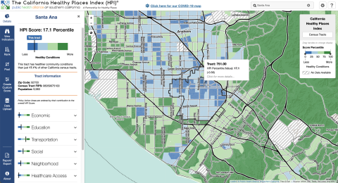
The HPI draws data about 25 community characteristics into a single indexed HPI score. The includes sub-scores for 8 “Policy Action Areas”: Economic, Education, Housing, Health Care Access, Neighborhood, Clean Environment, Transportation, and Social Factors. These scores are meant to be used to evaluate health geographically. Each policy action area includes the following individual indicators and weights:

ECONOMIC (0.32)

  • Poverty
  • Employment
  • Income

EDUCATION (0.19)

  • Pre-school enrollment
  • High school enrollment
  • Bachelors attainment

HEALTHCARE (0.05)

  • Insured adults

HOUSING (0.05)

  • Severe cost burden low income
  • Homeownership
  • Kitchen and plumbing
  • Crowding

NEIGHBORHOOD (0.08)

  • Retail jobs
  • Supermarket access
  • Parks
  • Tree canopy
  • Alcohol establishments

CLEAN ENVIRONMENT (0.05)

  • Diesel PM
  • Ozone
  • PM2.5
  • Drinking water

SOCIAL (0.10)

  • Two parent household
  • Voting

TRANSPORTATION (0.16)

  • Healthy community
  • Automobile access

*The steering committee for the HPI sought to include race/ethnicity as a 9th policy action area, but they were prohibited from doing so by state law which does not allow California state agencies to use race as a basis for public contracting.


The primary HPI Index is designed to align with life expectancy at birth as a predictive measure of community health status. However, the Healthy Places mapping tool can also be used to create custom scores using different indicators. The mapping tool includes detailed definitions of each indicator.

Each indicator is linked to a policy guide, which outlines concrete actions (e.g. best practices, emerging policy options) that local jurisdictions can take to improve HPI indicators. These actions are sometimes aimed at addressing direct links between policy and an action area, and other times aimed at addressed the root causes of an action area. The mapping tool also enables filtering results by “Decision support layers” like health outcomes, health risk behaviors, race/ethnicity, climate change effects, and other layers that the alliance identifies as important for advancing “resilient, equitable communities in California”. Geographies (e.g. census tracts) can also be compared by indicator using a ranking tool. The pool function can be used to create customized aggregations of data to map (e.g. adding several census-tracts together).

4. What scales (county, regional, neighborhood, census tract) can be seen through this data resource?

margauxf

Data is available at several different scales: census-tracts, congressional districts, state assembly districts, state senate districts, cities, core based statistical areas, elementary school districts, metropolitan planning organization and medical service study areas.  

10. What steps does a user need to take to produce analytically sharp or provocative data visualizations with this data resource?

margauxf

Creating maps by different combinations of indicators or geographic aggregations could be tinkered with to produce provocative data visualizations. Ranking scores can be used to draw distinction between different census tracts. However, clear inequities are evident even without these adjustments, with the HPI index score clearly demonstrating noticeable differences across geographies.